
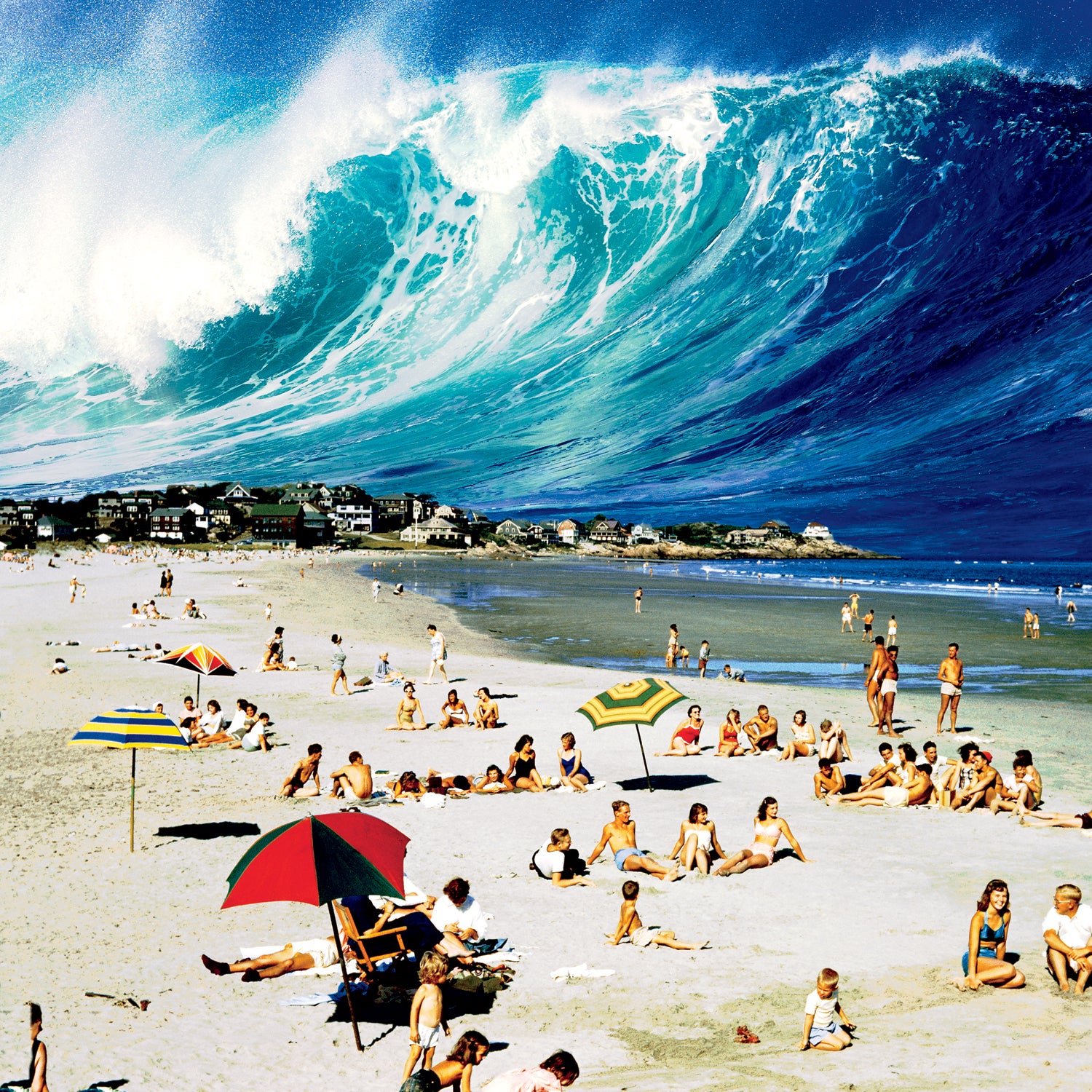
Pity poor Cassandra, blessed by Apollo with the power of prophecy, cursed with the fate of disbelief. She tells the people what’s coming. She suffers their laughter, absorbs their scorn. Then she watches her prediction come true. Yeah, you told us so, they’ll say as they bury the dead. Congratulations, jerk.
The Big-Shake, Big-Wave Theory
See how a megaquake would shake out in the Pacific NorthwestOregon Sea Grant geographer Corcoran
 Oregon Sea Grant geographer Corcoran
Seaside, Oregon
 Seaside, Oregon
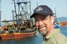
Patrick Corcoran feels her pain. It’s his job. Every day, he rises at dawn and goes out into the world to tell people to prepare to meet their doom. Or, rather, to prepare to escape it.
Corcoran is a professional geographer in Astoria, Oregon, a misty fishing port where the Columbia River meets the Pacific Ocean. He’s a high-energy guy, 50, with a little Billy Bob Thornton to his look. Loves his job and loves his coffee. Drives around in his Toyota Tacoma all day with an 11.5-foot-long Takayama paddleboard strapped to the rack. He’s a coastal natural-hazards specialist with Oregon Sea Grant, a marine version of an agricultural extension service affiliated with Oregon State University. Corcoran prophesies earthquakes and tsunamis five days a week.
“It breaks my heart to go out and tell people, ‘Hey, you know that place your grandparents immigrated to, the place you call home, that seaside cottage? Well, it turns out to be a high-risk disaster zone. Yeah. We get a massive earthquake every 300 to 500 years around here, and we’re due. They’re super bad. When it comes, it’s a monster. A full-rip nine.’ ”
By “full-rip nine” Corcoran means a magnitude-9.0 earthquake, the kind of massive offshore temblor that triggered the tsunami that killed 28,050 people in Japan on March 11, 2011. Geologists call them megaquakes. Geologists also call the Northwest coast of North America—from Vancouver Island down to Northern California—one of the likeliest next victims.
“When that earthquake hits, it’s going to shake for a long time,” says Corcoran. “Three to five minutes or more. You’re going to feel lucky to survive. Then guess what. You rode out the quake? Congratulations. Now you have 15 minutes to get above 50 feet of elevation. Fifteen minutes. You’re elderly and not very mobile? Sorry. Your condition does not change the geologic facts. It’s called a tsunami. The water’s coming. It can’t be stopped. Don’t ask Jesus to save you. Be your own Jesus.”
This is the prophecy that Corcoran offers to school groups, Rotary Clubs, town councils, and first responders up and down the Oregon coast. In Newport, Coos Bay, Seaside, Cannon Beach, Gearhart, Waldport, and Bandon, the people have heard his rap. And how do they respond?
“People are like”—he sticks his fingers in his ears—“Na-na-na-na-na-na-na! Can’t hear you!” He shrugs. “It’s human nature. People don’t like to get bad news.”
People, get ready. The bad news is coming.
The planet’s skin is a jigsaw puzzle of tectonic plates, 50 miles thick. Each piece is under constant pressure to move, building up elastic strain until the pressure overcomes the force of friction keeping it locked against its neighbor. The plate breaks free and snaps to a new position. The violence of this movement sends vibrations through the earth’s crust. An earthquake is born.
Tens of thousands of earthquakes happen around the world every year. Most are too small to be felt. Larger ones—6.0 to 8.0 on the Richter scale of magnitude1—go off nearly every month, but we take notice only when they hit populated targets like cities and schools. The earthquake that leveled Haiti last year was a 7.0. The 2008 quake that collapsed so many school buildings in central China was a 7.9.
Megaquakes, by contrast, are extremely rare. Prior to 2004, scientists hadn’t seen one of these 8.5-to-9.5 monsters since the 9.2- magnitude quake that hit Alaska on Good Friday 1964, the second-largest on record. Forty years passed without another one.
Then came Sumatra. Early on the morning of December 26, 2004, a 9.1 earthquake struck off the island’s northern coast, creating a tsunami that killed 227,898 people in Southeast Asia. It was the first megaquake in 40 years, but what grabbed the world’s attention was the tsunami—in large part because it was the first to occur in the age of digital video.
A second megaquake hit on February 27, 2010, when a 310-mile section of the Pacific plate ruptured off the coast of Chile. The event set off an 8.8 earthquake and generated a tsunami that left 521 dead.
Then, this year, a third megaquake struck off the coast of Japan, which boasts the world’s most tsunami-hardened coastline. Cities along the nation’s Pacific edge had erected massive protective walls built to withstand tsunamis generated by the largest earthquakes Japan had ever experienced—all in the 8.2-to-8.4 range. The March 11 quake was a 9.0, however, and not even the world’s largest seawall, the 1.2-mile, $1.5 billion barrier outside the city of Kamaishi, could hold back the water.
Footnotes
1. The Richter magnitude scale, developed by American geologist Charles Richter in 1935, must surely be one of the most confusing units of measurement in common usage. It’s a logarithmic scale, which means that the seismic waves sent out by a 7.0 quake are 10 times larger than those of a 6.0 quake. But the earth’s crust can only shake so hard. Once you get past a 6.0, the earthquake’s greater energy is expressed in longer shaking times. So the 6.9 Loma Prieta quake—the one that interrupted the 1989 World Series in San Francisco—lasted 15 seconds. The Great San Francisco Earthquake of 1906, estimated at somewhere between magnitude 7.7 and 8.3, lasted more than 45 seconds.
Coincidence? Or significant cluster? Some geologists, including Tom Parsons, a U.S. Geological Survey (USGS) geophysicist at the Pacific Coastal and Marine Sciences Center in Menlo Park, California, say it was chance. “Based on the evidence we’ve seen,” he says, “we don’t think that large, global earthquake clusters are anything more than coincidence.” Parsons and his colleague, University of Texas at El Paso seismologist Aaron Velasco, studied 30 years of major quakes (7.0 and larger) to see if they triggered subsequent 5.0-plus quakes. They found none.
Parsons’s study didn’t settle the question. Far from it, in fact. “Make no doubt about it: we’re in the middle of a global cluster of megaquakes,” says Chris Goldfinger, director of the Active Tectonics and Seafloor Mapping Lab at Oregon State University. “Everybody’s noticed it. There are seismologists who say it’s not statistically significant. But it’s happening. The reason it’s downplayed is that nobody’s figured out a mechanism—how and why they’re happening now.”
Goldfinger is no fringe scientist, and what’s especially troubling is that this sort of clustering has been seen before. Six of the world’s 16 largest recorded2 megaquakes happened between 1952 and 1964. More worrying, all six of the ’52–’64 cluster megaquakes occurred around the infamous Ring of Fire, the volcano-dotted arc that traces the edge of the Pacific plate. Of the remaining ten largest megaquakes, five have occurred since 2004. All five were along the Ring of Fire.
“Places that were previously considered safe, well, they’re now being reconsidered,” Goldfinger says.
The Pacific Northwest is at the very top of that list.
The problem is the Cascadia subduction zone, or CSZ. This is an enormous fault that parallels the West Coast for about 740 miles, from the Brooks Peninsula on Vancouver Island to Cape Mendocino in Northern California. It sits about 50 miles off the coast, marking the line where the North American plate meets the Juan de Fuca plate. The CSZ ends where the San Andreas Fault begins, about 100 miles north of San Francisco.
The San Andreas you’re familiar with. It’s a transform fault—one characterized by lateral movement—where the Pacific plate grinds north past the North American plate. The creeping section of the San Andreas, south of the Bay Area, sheds its built-up strain in frequent small earthquakes, like a forest that burns so often it never has the chance to stockpile fuel. The northern and southern ends of the fault aren’t moving, which leads geologists to believe they eventually will lurch, resulting in a quake as large as 8.1.
2. “Largest recorded” means, in essence, dating back to 1880, when modern seismograph technology began to record the vibrations from earthquakes.
The CSZ is a different beast. Up in the Northwest, the plates don’t merely grind past each other. The heavier Juan de Fuca plate dives under (subducts) the lighter North American plate at a rate of 1.6 inches per year. Hence, a subduction zone. Transform faults like the San Andreas are capable of throwing off major quakes—up to 8.1—but not megaquakes. Rule of thumb: the longer the fault rupture, the bigger the quake. Only subduction zones have the length necessary to generate the mammoth 9.0’s.
The CSZ is especially deceptive because it’s been inactive for all of recorded history.3 “Seismically quiet as Kansas,” says Robert Yeats, the éminence grise of West Coast seismology and the author of Living with Earthquakes in the Pacific Northwest: A Survivor’s Guide. “Or so we thought.”
Back in the 1970s and ’80s, Yeats and others attributed the CSZ’s quiescence to a kind of hyper-lubrication. The subduction zone must be so slippery, they thought, that the Juan de Fuca plate is sliding under the North American plate as if on a bed of axle grease.
Then in 1979, John Adams, a New Zealand geologist working in Canada, noticed something funny. Going over data from the National Geodetic Survey, America’s surveying corps, Adams found that highways along the Washington and Oregon coast were gaining about one to two millimeters of elevation per year. His findings held all the ominous portent of a line from a Tommy Lee Jones disaster movie: Um, guys, why are all the roads rising?
Other evidence compounded the concern. In 1986, Brian Atwater, a researcher at the USGS, was canoeing along the shore of Willapa Bay, north of the Oregon-Washington state line, during a low tide. He noticed evidence of a “ghost forest,” old cedar stumps half-buried in the tidal marshes. The stumps sparked a memory; at a talk by USGS geologist Tom Ovenshine years earlier, Atwater had heard that spruce and willow thickets in Alaska’s Cook Inlet had dropped five feet during the 1964 Good Friday quake. Could the same thing have happened here? Tree-ring tests by colleagues confirmed that the Willapa Bay forest died in 1700. So did other buried estuary stumps along Washington’s southern coast. That date corresponded with historical accounts of a massive tsunami striking the islands of Japan in January 1700.
This startling evidence made seismologists sit up and take notice. Clearly, the Cascadia subduction zone had ruptured in a megaquake in 1700, down-dropping the Northwest coast several feet in elevation and unleashing a killer tsunami.
As for the rising roads, well, think of it this way. Take a fishing rod and jam the tip up against a low garden wall. Now hold the rod at the butt and slowly push the tip into the wall. As tension builds, the rod will bow upward under the strain. That, in a nutshell, is what the Northwest coast is doing.
3. Which, in the Pacific Northwest, isn’t saying much. Indians have been here for 10,000 years, but written history arrived only in the early 19th century.
“The new evidence meant that the Juan de Fuca plate wasn’t sliding easily under the North American plate,” says Yeats. “It meant that the two plates were completely locked.” Pressure has been building and building, for 311 years. If you are a geologist, at this point what runs through your mind is, Holy shit.
Of course, the magic number could be 500 years, or (gulp) 244. For the past decade, Chris Goldfinger has been pulling samples from landslide zones off the Oregon coast.4 By interpreting the cross-sections, he found a record of 19 full-rip nines in the past 10,000 years—a rate of about one every 500 years. He also discovered 22 CSZ quakes measuring 8.0 to 8.5. That means the CSZ has caused 41 major quakes in the past 10,000 years, or one every 244 years.
So what we have now is a 740-mile section of the world’s most seismically active zone, the Ring of Fire, that has been building up elastic strain for 311 years. The North American plate, by some estimates, is now springloaded to leap more than 57 feet west and drop three to six feet in elevation at the coast. The CSZ always ruptures in one of two ways: as a kielbasa (along its entire length) or as one of numerous breakfast-link sausages (a single 200-mile segment). A breakfast link would set off an 8.0, limiting damage to a portion of the coast. The whole kielbasa would be a 9.0-plus that rocks the entire Northwest coast.
“The amount of devastation is going to be unbelievable,” Rob Witter, a geologist with the USGS’s Alaska Science Center, told the Oregonian in 2009. “It may not happen in a person’s lifetime, but if it does, it’s going to be equivalent to a Katrina-like event.”
Or, as Goldfinger puts it, “If it did happen, it can happen.”
This is how it will happen.
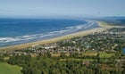
Let’s pick a day: June 22, 2012. It’s a gorgeous Friday afternoon in the Pacific Northwest, 75 degrees and sunny. It’s been raining for weeks, and in Seattle the freeways are jammed with people fleeing the city to enjoy the rare sunshine. Same story in Portland. Out on the coast, the beach towns are thrumming with tourists. In Ocean Shores, Washington, teenagers race rental scooters up and down the town’s six-mile-long peninsula. Merchants are happy. The motels are nearly full. Down in bustling Seaside, Oregon, 75 miles away, shopkeepers are doing a snappy trade in T-shirts, towels, flip-flops, and sunscreen. Eight miles south in tony Cannon Beach, restaurants are booking tables for 7 p.m.
4. During a subduction-zone earthquake, landslides occur on the ocean floor just as they do on dry land. Unlike dry-land slides, however, the most likely thing that can set off a seabed slide is an earthquake. So they make excellent markers of subduction-zone events.
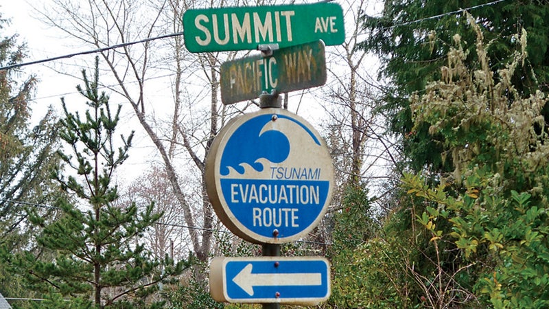
Officials in each town are aware of the CSZ megaquake-and-tsunami risk. They’ve all printed up evacuation-route maps. In Cannon Beach, they’ve even talked about building a new city hall that would double as a tsunami safe house. But nobody has ever had the money to build anything, other than installing tsunami-warning sirens.
Not that there will be much warning. Even today, when it comes to earthquake prediction, the earth remains a poker player without a tell. “The best we can do is let people know how the shaking will spread once an earthquake starts,” says University of Washington geologist John Vidale, director of the Seattle-based Pacific Northwest Seismic Network. “Japan’s system is the best in the world. Within 30 seconds of the start of the March 11 earthquake, they broadcast a warning that it would be at least a magnitude 8.0.” No such system yet exists in the United States, though Vidale’s and other teams are working on one.
“Let me tell you this,” Patrick Corcoran says as we stroll down Broadway, Seaside’s main drag. “There’s a shop a couple blocks up the street that sells T-shirts that say TSUNAMI EVACUATION PLAN: (1) GRAB BEER. (2) RUN LIKE HELL.”
“And honestly,” he says, “that’s not a bad strategy.”
MINUTE 0:00
After 312 years, the Cascadia subduction zone can no longer contain the strain. It ruptures at a spot 55 miles west of Cannon Beach and quickly spreads along 700 miles of its 740-mile length. The North American plate slips anywhere from 45 to 57 feet to the southwest, sliding over the Juan de Fuca plate. It doesn’t happen instantly. A mass that large—remember, we’re talking about crust more than 50 miles deep—takes time to move. But upon its first lunge, the CSZ sends out a pressure wave, or P-wave, that travels through the earth’s crust at 13,000 miles per hour. It reaches the West Coast within ten seconds. That first P-wave, the earthquake’s leading edge, hits Ocean Shores, Cannon Beach, and Seaside. Thirty seconds later it reaches Portland; in 50 seconds, it hits Seattle. At the University of Washington’s Seismology Lab in Seattle, the seismometers jump. Geologists read the data and declare the earthquake a 9.1. It’s the full rip.
The first few seconds feel like any other strong earthquake: jarring. “The pressure wave is like a jackhammer, rat-tat-tat-tat-tat,” explains Goldfinger, who happened to be outside Tokyo—at a geology conference to discuss the Sumatra earthquake—during the March 11 Sendai quake.
The sound is majestic and awesome. In his book A Dangerous Place, author Marc Reisner wrote of his experience in San Francisco during the 1989 Loma Prieta earthquake: “What I remember most vividly is the grinding, the unearthly noise of great surfaces and structures grating together.” Chris Goldfinger recalled the sound of leaves rattling on trees. In Japanese houses, the sound was an unrelenting clatter of metal and glass.
In the offices, apartments, and high-rise condos of Seattle and Portland, uncertainty creeps into half a million heads: Freeze or flee? In videos shot during the Japanese megaquake, the overwhelming emotion on display isn’t panic or raw fear. It’s focused anxiety and strategic calculation. They are trying to figure out what to do.
“People in buildings die in an earthquake one of two ways,” Corcoran says. “Either the building pancakes on top of them, or they run outside and a gargoyle falls off and hits them on the head. You need to know: Is your building a pancake or a gargoyle?”
Instinct and old memories kick in. Many people duck and cover under a strong table. (Actually not the worst plan.) Others recall their mothers telling them to jump into the bathtub. (Wrong natural disaster! The bathtub’s for tornadoes.) Out on the roads, traffic slows to a halt, like a scene in one of those movies where invading aliens power down the planet.5 Some drivers get out and crouch next to their cars. Others stand and spectate. By and large, people remain calm.
Except, that is, on Seattle’s Alaskan Way Viaduct. The elevated double-decker expressway running along Elliott Bay begins to rock with the first P-wave. For more than two decades, seismic engineers have warned that the Viaduct, built in the 1950s, will collapse in a major quake.6 Work on a $3.1 billion tunnel to replace it started in 2008, but the project has been delayed by political wrangling and soil problems. Now the Viaduct turns into a two-story demolition derby as people make desperate bids to reach the nearest off-ramp before the thing buckles. In the coming minutes, some sections will pancake, while others will topple completely. Drivers will be crushed beneath tons of concrete.
Two hundred miles south, in the trinket shops of Seaside, merchandise hops off the shelves. At the Purple Pelican, glass seahorses, swans, and custom-painted wineglasses crash to the floor. Half-drained beer pints dance off the bar at Pudgy’s Broiler. On the Seaside Carousel, fathers pull their daughters off painted horses and leap from the turntable. Everybody knows it’s an earthquake. Nobody knows yet that it’s the big one.
Meanwhile, 50 miles offshore, the movement of the North American plate displaces a massive volume of seawater. A standing wave just a few feet tall appears at the surface, then splits in two. One half heads west toward Japan at a speed approaching 450 miles an hour. It will reach Honshu, the main island, in ten hours. The other half heads east. It will hit the coasts of Oregon, Washington, and Vancouver Island in 20 minutes.
MINUTE 1:00
After the earthquake’s initial pressure wave, there’s a short lull. Then the S-waves arrive. These shear waves travel more slowly than the pressure wave, but they’re longer-lasting. A shear wave is like the wave that runs down a garden hose when you whip it. “It’s the S-waves that really do the damage,” says Goldfinger. “It feels like you’re on a boat. Everything turns fluid.” People start feeling dizzy. Some drop and hug the ground.
The Pacific Northwest Seismic Network flashes an earthquake alert to first responders, government officials, and media outlets. The network’s instruments indicate that this is a full subduction-zone event, not a short fault rupture. “Expect shaking to continue for up to five minutes,” the alert says. “Heavy aftershocks will follow.”
5. A study of Japanese drivers during a 2003 earthquake found that 90 percent had slowed to a stop within about ten seconds of the start of the earthquake.
6. The Viaduct is a near carbon copy of the Bay Area’s infamous Cypress Structure, a one-mile stretch of the Nimitz Freeway that pancaked during the Loma Prieta earthquake, killing 42 motorists.
In Seattle and Portland, the strong shaking begins to induce liquefaction,7 a process in which the sandy soil that portions of both cities are built on turns into a thick, slurry-like liquid. Parts of Portland rest atop sediment laid down by the Willamette River, and Seattle’s waterfront sits on tidal flats overtopped by loose fill. In a quake, this unconsolidated fill loses its ability to support heavy structures. Wide cracks open in the streets. Sections of Seattle’s waterfront collapse. Liquefied soil pushes against the city’s retaining seawall, which has been weakened by gribbles.8
On the Oregon and Washington coasts, the S-waves turn the landscape into a rolling sea. Tourists struggle to stay on their feet. Older buildings shift off their foundations. In Seaside, the 1924 bridge that carries Broadway across the Necanicum River can’t handle this dance. It twists, buckles, and collapses.
MINUTE 2:00
People start checking their watches. Nobody can believe an earthquake could keep going this long. For that they can blame the unique features of the CSZ.
“Because there’s so much sediment on it, the CSZ is very smooth,” says Goldfinger. “Once it gets going, there are no irregularities on its surface to stop it. If there’s no reason for it to stop, it’ll just keep going until it dissipates all 300-odd years of elastic strain.”
Japan’s March 11 quake lasted more than five minutes. That’s longer than it takes a pot of coffee to brew. And that’s not good.
“Most modern buildings weren’t designed to withstand three to four minutes of shaking,” says Peter Yanev. One of the leading seismic-engineering consultants, Yanev has investigated more than a 100 quakes around the world. “Almost none of the buildings in Seattle were designed for a megaquake.”
Most unreinforced-masonry buildings9 in Portland and Seattle can survive a 45-second quake, like the magnitude-6.8 Nisqually quake that hit Seattle in 2001. But the longer they’re shaken, the weaker the structures become. “The difference between 40 seconds and four minutes is like the difference between a head-on collision at four miles an hour versus 40,” says Yanev.
7. About liquefaction: Sandy soils are held together by friction. But when you add water (the ground under Seattle and Portland is typically saturated at the end of a rainy Pacific Northwest spring) and shake, the bonds of friction break. The most famous example occurred during the Loma Prieta quake, when the ground beneath San Francisco’s Marina District turned to slop.
8. That’s right, gribbles: flea-size isopods that eat wood softened up by salt water. They’ve been munching away at Seattle’s Elliott Bay seawall for decades. Each gribble has four mouths, a healthy appetite, and a symbiotic partnership with a bacterium that breaks down creosote.
9. These buildings, with load-bearing walls made of brick or masonry, were typical in the early 1900s. They tend to collapse like the proverbial ton of bricks. California banned the construction technique as early as 1933 and required existing structures to undergo seismic retrofitting in the 1970s. In Seattle, about one-third of all unreinforced-masonry buildings have been retrofitted.
Buildings begin to shake apart at the two-minute mark. Bricks rain onto sidewalks. In house basements, hot-water heaters topple and rupture natural-gas pipes. Fires flare. In some communities, fire crews can’t respond because the earthquake has warped garage-door frames. If they can get out, it’s a crapshoot as to whether they’ll have enough water pressure to fight the fire, because the earthquake has ruptured water lines.10
Along Seattle’s waterfront, fire isn’t the problem. By minute two, piers begin to collapse. Ye Olde Curiosity Shop and Ivar’s Acres of Clams, two fixtures of the waterfront, slump into the bay. Power lines snap across the Northwest. There are no active nuclear facilities in the area, but along the Columbia River, high-voltage transmission lines connected to the river’s hydroelectric dams sway and topple into the river. Power grids across the West experience dramatic drops in supply.
In Portland, a city famous for its bridges, the spans begin to buckle. The Marquam Bridge carries Interstate 5 over the Willamette River. In 1995, engineers installed shock absorbers and restraint cables throughout the structure as part of a seismic retrofit. As a result, it remains upright. The Fremont Bridge, which holds Interstate 405, was built in 1973. It topples into the Willamette. Along U.S. Highway 101, the coast’s main north-south corridor, dozens of bridges go down.
In Seaside and Cannon Beach, lifeguards blow their whistles and stagger down the shoreline to call people in from the water. They know what’s coming. In Ocean Shores, there are no lifeguards. Most tourists stay put.
MINUTE 3:00
As the shaking continues, the northern Pacific coastline sinks. The elastic strain that caused roads to rise slowly over 312 years is being released in a matter of minutes. The coast drops—whump—five feet in elevation.
There are more than 900 modern high-rise buildings in Vancouver, Seattle, and Portland. More than half were constructed before 1997, when most urban design codes were updated to reflect the possibility of a CSZ megaquake. In downtown Seattle, there are reports of glass-and-steel office buildings buckling. This is hard to believe: weren’t they designed to flex and roll with an earthquake? Well, yes. But not this kind of earthquake. Most modern 20-to-40-story buildings are designed to survive nearby crustal earthquakes but not large subduction-zone events. Crustal earthquakes send out high-frequency waves; subduction-zone quakes send out low-frequency waves over longer distances. In some parts of Seattle, those waves react to Seattle’s soft soil like sound waves hitting a bullhorn. Along the waterfront, Harbor Island, and the Duwamish Valley, ground motion will be two to five times as violent, and last twice as long, as it would at a comparable site on bedrock. In those areas, some buildings will collapse.
The Space Needle is not collapsing. In fact, it may be the safest building in town. With its tripod legs, inner steel core, and massive underground foundation, the Needle was built to survive 100-mph winds and a 9.0 earthquake. But low-frequency seismic waves have sent the Needle into a side-to-side whip like a car’s antenna. Now 78 visitors trapped in the top house stagger to walls and girders like storm-tossed sailors. Some splay out flat on the floor. The early stages of seasickness rumble in their guts. One woman recalls the spectacular view she enjoyed a mere three minutes ago and thinks, Boy, it’s a long 600 feet down.
MINUTE 5:00
Five minutes and 17 seconds after it began, the earthquake stops. The University of Washington Seismology Lab tags it as the largest in the region’s recorded history. Globally, it ranks as the third-largest ever recorded by modern seismic instruments.
10. In terms of fire, Seattle’s actually in better shape than most other cities, having spent $197 million in 2004 to quake-harden its fire units. The SFD’s firehouse doors all open. The department has pumps and mile-long hoses to draw water directly from Puget Sound, Lake Washington, or any of nine reservoirs.
The worst is over for Seattle and Portland. But in the beach towns, the countdown has begun. A tsunami that will inundate the coastline is now about 35 miles offshore. It will reach dry land in a little more than 15 minutes. There are 7,500 people in the inundation zone in Ocean Shores. Seaside: 15,000. Cannon Beach: 7,800.
Take the advice on the T-shirt. Grab beer. Run like hell.
MINUTE 6:00
The beach at Seaside is one of the glories of the Oregon coast. It’s flat, wide, vanilla-gray, and gorgeous. The lifeguards continue to herd swimmers and sunbathers away, but some are unconvinced. They don’t hear the tsunami sirens, or, having been through tests of the sirens in the past, ignore them.11 “This is no joke,” one tells a visitor. “You need to move. Now.” Move where? people ask. “Walk up Broadway,” the lifeguard says, “and don’t stop until you’re at the top of a hill!”
The walk to Broadway takes three minutes. At this point the beachgoers are faced with a life-or-death decision. A crowd has formed at the doors to the Wyndham resort, an eight-story beachside hotel-and-condo complex. People are shouting and pushing their way through the doors, calling out for family members.
Hard data has never been more valuable to these people. “Is it tall enough?” one person wonders aloud. “Will it stand?” another asks. The Wyndham’s windows are all shattered, but otherwise it looks structurally sound. It’s a long half-mile trek to high ground, with two bridges to cross. Rumors ricochet around the crowd: The bridge is down! No, it’s standing! Both pieces of information are true. There are seven critical bridges in Seaside. Some have survived the earthquake, some haven’t. The manager of the Wyndham appeals for calm. He’s old enough to recall the Who concert, Cincinnati, 1980, the killing crush of crowds and doors. He makes an appeal: Those who can walk should walk—Wyndham staff are already leading guests to high ground.
“How far is it?” someone asks. “Half a mile,” the manager says. “Oh, Lord, I’d never make it,” says an elderly woman in a pink T-shirt. “I can’t walk that far.”
For the beachgoers, two precious minutes are wasted mulling over the best strategy. A general culling takes place. The firm and the fleet decide to keep walking. The elderly, the broken-down, the obese, the calculating, and the stubborn file into the Wyndham. Nobody has told them that the citywide power outage has knocked the elevators out of commission. The crowd slowly trudges up eight flights of stairs. Strong men and women, strangers, band together in teams to carry the elderly and disabled up to the roof.
11. In Japanese coastal towns, that’s exactly what happened in March. A tsunami alarm a few months earlier had sent locals scurrying for high ground. The water came in like a lamb, less than a meter high.
A parade of stunned humanity files up Broadway. Beachgoers who came away without their shoes now find the sidewalks littered with broken glass. They wrap their feet in T-shirts until they reach the Old Crab gift shop. There, one guy starts dumping armloads of flip-flops onto the sidewalk. “If your feet are bleeding, I have sandals!” he yells. “Please keep moving!”
Earthquake debris has made driving impossible. Still, some people try. They honk their horns and attempt to maneuver through the crowds. Eventually they abandon their cars and walk.
MINUTE 8:00
The first wave is about 25 miles offshore. It slows as it reaches shallower depths but loses little of its power. The water along the coast begins to recede.
In the major fishing harbors, a panicked exodus is under way. During the quake, boat owners recalled that tsunamis pass peacefully under vessels on the open ocean. They also remembered images of container ships perched atop four-story buildings in Sendai. Now they’re motoring all-out for open water. In Westport, Washington, a charter-fishing port directly south of Ocean Shores, dozens of vessels parade out of Grays Harbor. Fifty miles south, in Astoria, commercial fishing trawlers try to outrace the tsunami by heading up the Columbia River. They aren’t aware that a dam upriver has been damaged by the quake and is in imminent danger of breach.
In subduction-zone quakenamis like the one that hit Sumatra in 2004, tourists are often the most clueless about what to do. In Seaside, Broadway has become a parade of hurting-but-helping humanity, all heading east. Except … there’s one solitary figure weaving his way west. Toward the ocean. He’s kind of a dirtbag. No shirt, just an old swimsuit and huaraches, rocking the white-dude dreads. Under his arm is a surfboard.
One of the retreating lifeguards spots him. “Dude!” he calls out. “Don’t do it!”
The surfer waves to the lifeguard and continues walking. Three days later they’ll find pieces of his board. His body will never be found.12
12. Crazy as it seems, he won’t be the only one on the beach. With every tsunami warning, there’s always a small contingent of mixed nuts who drift down to watch the action and form a flash mob of Darwin Award nominees. At any rate, it’s physically impossible to surf a tsunami. Often called tidal waves, they aren’t “waves” at all. There is no face, no pipe, no curl. A tsunami is more like a storm surge. Common waves are created by wind energy. Tsunamis are created by the massive displacement of water, and terrifying Japanese woodblock prints notwithstanding, they don’t break like wind waves. They come ashore more like enormous high tides, with a low, inches-high leading edge backed by a steadily rising onrush of water. A 40-foot-high tsunami does not come ashore as a 40-foot-high wave. It steadily builds to that height with each successive pulse.
MINUTE 13:00
In Ocean Shores, which is built on a sandspit six miles long and three miles wide, high ground is miles away. Most locals have jumped into their cars, making their way slowly north on Point Brown Avenue. Liquefaction has chopped up the road, though. Only four-wheel-drive trucks and SUVs can get past the sloppy sand breaks. A few good Samaritans encourage others to hop in the backs of their flatbeds. Others blow past.
In Cannon Beach, a power outage prevents town officials from broadcasting a tsunami warning. A city planner runs down to Haystack Rock, the town’s iconic landmark, with a whistle. He blows it wildly and yells at two dozen out-of-towners, who seem mesmerized by the receding tide and the bare seafloor. A few listen and follow him to the Ecola Creek bridge. But it has collapsed, creating a pinch point. For years the town had discussed the possibility of retrofitting the bridge. City officials wanted to build a new $3 million structure strong enough to withstand a tsunami, but nobody could ever come up with the funds.13
MINUTE 17:00
The crowds in Seaside continue up Broadway, crossing Highway 101, filing past the Chamber of Commerce and Broadway School. Finally, at Wahanna Road, a half-mile from the beach, the road begins to climb. At a lookout point, somebody passes a pair of binoculars around. The tide has gone out. And then suddenly it rushes back in.
At Oregon State University’s O.H. Hinsdale Wave Research Laboratory, one of the world’s leading tsunami-research centers, wave hydrologists have run sophisticated simulations of a CSZ-generated tsunami hitting Seaside, Cannon Beach, and other coastal towns. The findings do not suggest sticking around. “A lot depends on wave speed,” says Solomon Yim, director of the lab. “We found that in some blocks of densely packed houses, the first line of houses took the brunt and the second line was shielded.” The specifics of the tests haven’t been released to the public for fear of causing an upheaval in the local real estate market. “If your building was one that did not survive the simulated tsunami,” says Yim, “it would be … not so good for the resale value, you see.”
MINUTE 18:00
The leading edge of the tsunami hits the beach at Seaside. From the roof of the Wyndham, hundreds of people watch and record the water crashing ashore and flowing up Broadway. It comes in like a tide moving at flash-flood speed. Just a trickle at first, but within seconds it’s knee-high and then lapping at windows.
By the time it neared shore, the pulse of water had slowed to about 30 miles per hour. On dry land, it moves inland at a speed of 11 mph. To outpace the tsunami, you’d have to run at least a 5:30 mile.
The Wyndham and its neighbor, the five-story Shilo Inn, act like a nozzle. The water, black and powerful, jets through the opening between them: Broadway. Stragglers try to run, but the flow sweeps their feet from under them. Some hold on to lampposts. The water pushes wood, metal, and glass into them. The surge is strong enough to bend two-inch metal pipes.
13. “They’re debating about whether they should build a $7 million bridge,” Corcoran says. “You don’t need a $7 million bridge high enough and strong enough to withstand the quake and the tsunami! You need a $1 million bridge strong enough to survive the earthquake, so people can cross it to escape the tsunami. However it’s built, it’s not going to survive the tsunami.“
One- and two-story buildings groan. The water is reaching their rooflines and twisting their foundations. Some begin to lift and float up Broadway.
“Seals!” someone shouts. True. There are seals swimming up Broadway alongside the bobbing SUVs. The 75-year-old Seaside Aquarium, a several-story wooden building, did not survive the initial earthquake. Two of its harbor seals were crushed by falling debris. Two others were killed by the onrushing tsunami. The survivors now swim around the drowned town, confused by the water’s darkness, its oily taste and smell.
The water keeps rising. It has overtaken the third floor of the Shilo Inn.
MINUTE 19:00
In Cannon Beach, the tsunami swallows up half of Haystack Rock and rushes up to the steps of City Hall. In Ocean Shores, anybody who hasn’t gotten out yet won’t. A few holdouts take refuge in another Shilo Inn,14 at four stories the tallest building in town. It’s not tall enough, as its staff have warned those who stay behind. The ocean has now entirely overtaken Ocean Shores.
In Seaside, the crowd atop the Wyndham watches in horror as the water overtops the Shilo Inn across the street. People on rooftops leap into the water and attempt to swim to the Wyndham. But tsunami water is thick with sediment, wood, metal, and glass. It’s difficult to move in. Gas fumes from broken lines make it hard to breathe. Many who try to swim drown. Those who cling to floating objects have a better chance of survival.
MINUTE 21:00
People in Seattle and Portland—those who have power and whose cellular networks are still functioning—watch live footage of the tsunami on their smartphones, shot by news helicopters. They wonder if it will hit the cities.
It probably won’t. To reach Portland, the tsunami would have to muscle its way up 75 miles of the Columbia River and hang a hard right at the Willamette River. Seattle is similarly protected by the topography of Puget Sound. The tsunami will likely slosh up the sides of the Strait of Juan de Fuca and expend its residual energy on the western shore of rural, sparsely populated Whidbey Island.
14. I’m not picking on the Shilo Inn company, which has 40 convenient locations in 10 western states. They just happen to site some of their hotels on prime oceanfront property. Those beachside resorts are big enough to lure panicked tsunami evacuees but often not tall enough to provide refuge from the flood. Guests would be evacuated.
There could be a strange mini-tsunami effect in Puget Sound, however. Hydrologists call it a seiche. It’s like what happens when you kick a dog’s water bowl. The water sloshes back and forth in slowly diminishing waves. A handful of people who wander down to shore to watch the arrival of the tsunami will get sucked into the sound.
MINUTE 60:00
Secondary tsunami pulses batter the coast. They’ll continue for eight to ten hours.
Survivors in Ocean Shores, Seaside, and Cannon Beach won’t get their towns back for days or weeks. Over the next month, more than 2,000 aftershocks will hit. Eighty-three of those will be big enough to be felt. Five will be above magnitude 7.0.
The Northwest coastline’s elevation has dropped three to five feet. Normal high tides will now be flooding houses, hotels, and streets twice a day. In Ocean Shores, the situation is especially dire. Prior to the megaquake, the highest point on the sandbar peninsula was 14 feet in elevation. Now it’s nine. The lobby of the Shilo Inn, now a wrecked shell, is lower than sea level.
Among disaster-relief experts, the calamities of the past decade have forced the realization of a truism: first responders are victims; victims are first responders. In other words, firefighters, police, military, and medical workers are among those killed and injured in the disaster. And civilian victims (the able-bodied, at least) become de facto first responders.
President Obama makes unsuccessful attempts to reach Oregon governor John Kitzhaber and Washington governor Christine Gregoire. A massive surge of traffic has crashed the Verizon, AT&T, and T-Mobile networks across the Northwest. But, having witnessed FEMA’s dismal performance after Hurricane Katrina and during the Gulf of Mexico oil spill, nobody is counting on the federal cavalry to come to the rescue. The Red Cross and other groups show up within hours. But in the year 2012, most disaster recovery is DIY.
That’s especially true along the coast, where each town has been islandized. Highway 101 has been snipped into a hundred pieces. Nearly all bridges are down. State, county, and town officials quickly set up staging areas, but there’s very little top-down coordination. Food, shelter, medical care, and fuel are the immediate priorities. Hospitals are overwhelmed. Local social networks come into play. In Seaside and Cannon Beach, city officials work with fishermen and hunters, who have boats and ATVs. Air National Guard helicopters ferry the injured from coastal towns to hospitals in Richland, Washington; Bend, Oregon; and Salt Lake City.
The Newport, Oregon, Walmart becomes one of the coast’s critical staging points for both food and material. As they did during Hurricane Katrina, Walmart executives in Bentonville, Arkansas, get word to their store managers: Do whatever it takes to help your communities. Autonomy is yours. The company’s distribution network begins moving food, medicine, and building supplies to Oakland and Long Beach, California, where they will be loaded onto chartered container ships and sent to Newport. From there, a mosquito fleet of private boats moves the goods the final miles to affected communities. Other stores—Safeway, Home Depot, and Costco—follow Walmart’s lead. The U.S. Navy stations a floating fuel dock in Newport to keep the flotilla moving.
EPILOGUE
Six months after the megaquake and tsunami, the official death toll stands at 7,241. More than 3,200 were killed in or around Seattle, Portland, and Vancouver. Many died when older houses collapsed. Others were killed by falling objects or died in fires. A number succumbed to heart attacks, and 679 were killed by the tsunami.
That’s far fewer than the tens of thousands who died in the Japanese tsunami of 2011. The difference isn’t attributable to better planning, stronger buildings, or quicker evacuations. It’s simply a function of population. Millions of people live on the coast of Japan, whereas the Washington and Oregon coasts are barely inhabited. There are no nuclear power plants along the coast of either state.
State and federal officials wrestle with the question of rebuilding Ocean Shores. In the end, the town is abandoned to the sea. The National Oceanic and Atmospheric Administration partners with the Environmental Protection Agency to remove hundreds of fuel-oil tanks and other hazardous material to prevent leaching into the ocean.
By its one-year anniversary, the event has become known as the Great Cascadia Earthquake. It was the most powerful earthquake known to have hit the continental United States, and one of the three most powerful earthquakes since modern record-keeping began. It triggered tsunami surges of up to 51 feet in Ocean Shores, Seaside, Cannon Beach, Newport, and other coastal towns and traveled up to six miles inland. In addition to the deaths, FEMA confirmed 27,567 injured and 135 people missing across 37 counties, as well as more than 42,500 buildings damaged or destroyed. One dam on the Columbia River came close to collapse. Around 3.5 million households in the Pacific Northwest were left without electricity, and one million without water. Estimates placed insured losses from the earthquake alone at $5.5 billion to $14.6 billion. The overall cost could exceed $30 billion, making it one of the most expensive natural disasters in American history.
The earthquake moved North America 57 feet west and shifted the earth on its axis by estimates of between 8 and 20 inches.
The Great Cascadia Earthquake also left a number of people jobless, including Patrick Corcoran. That didn’t last long, though. Within six months, he is running FEMA’s statewide recovery effort. People on the coast recognize him now and then from his tsunami-preparedness work before the disaster. And they thank him.
“All those years,” he’d tell people, “I kind of felt like the boy who cried wolf. But what people don’t remember is how the story turned out. In the end, there really was a wolf.”