Last week, scientists released a monumental interactive catalog that tracks 94 ancient tectonic plates lurking deep within Earth’s mantle, a resource they’re calling an “Atlas of the Underworld.”
Although scientists have known for decades that tectonic plates plunge into the Earth’s interior at subduction zones, until recently, those plates disappeared off the geological map once they stopped generating earthquakes, which happens after they’re around 670km below the surface. In the last few years, seismic tomography, which uses waves from earthquakes to make images of the planet’s interior, has restored their visibility. It has revealed subducted plates sinking in the mantle all the way down to the core-mantle boundary, 2,900km below Earth’s surface.
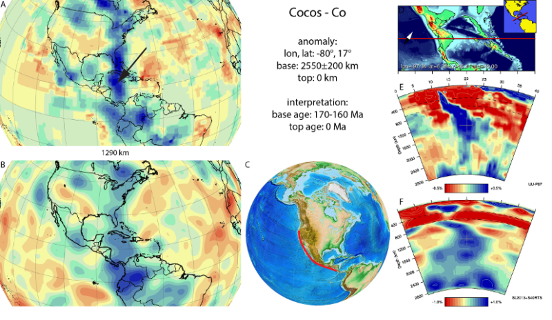
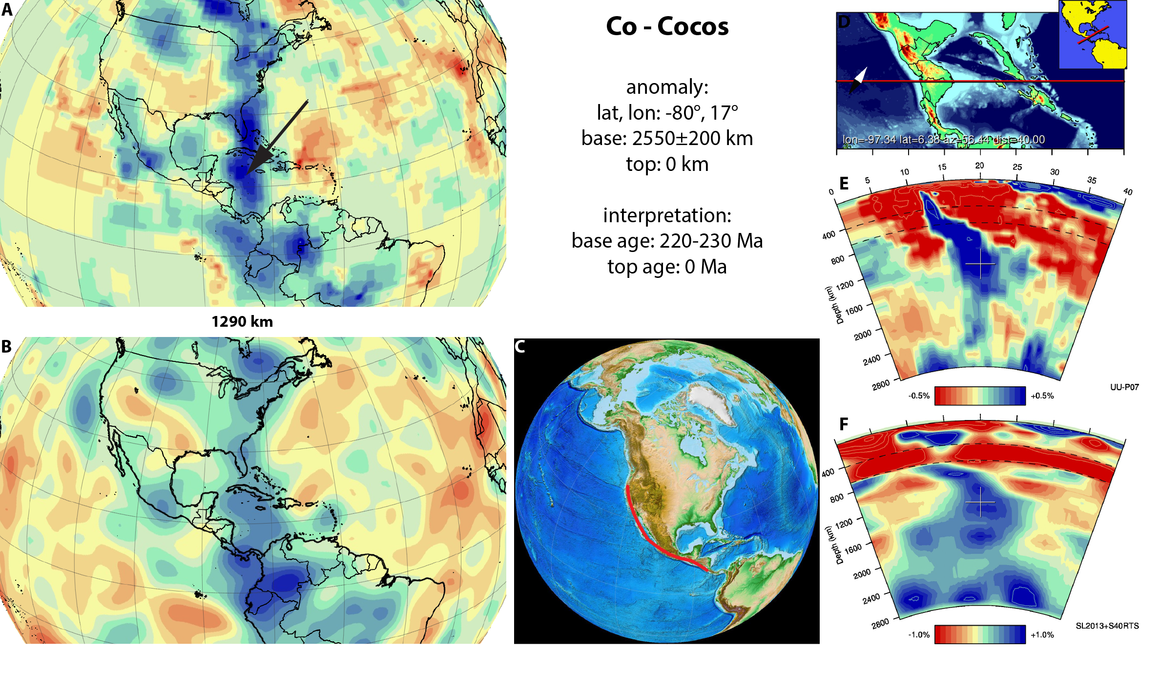
Now, Dutch scientists Douwe van der Meer, Douwe van Hinsbergen, and Wim Spakman of Utrecht University have catalogued 94 separate pieces of ancient tectonic plates, called “slabs,” in the mantle, linking them to dates where geological events happened while they were on the surface. Some subducted almost 300 million years ago, while others can be traced to active faults, such as those along the western coast of the Americas.
A 17-year labor of friendship
For the two Douwes, who have been pals since their college days in the 1990s, this has been a 17-year labor of friendship. “All in all, this was 17 years of work spanning my entire career, and Douwe’s long-term hobby!” van Hinsbergen told Ars.
It began in 2000 with Douwe van der Meer’s masters thesis on the remains of tectonic plates beneath the Caribbean, under the supervision of Wim Spakman. Douwe van Hinsbergen did similar work on remnants of the Tethys, an ancient ocean basin. The slab remains of the ocean floor now lie in the mantle beneath Southern Europe and Arabia.
“Over the years, this grew into a hobby: ‘Let’s do another slab this week!’” van Hinsbergen told me.
In 2010 they published their first iteration of the project, with 28 slabs. By 2015, they had built the website, and in 2016 the team presented their expanded atlas at the fall meeting of the American Geophysical Union. Since then, their focus has been on the peer-reviewed paper to be published Thursday in the journal Tectonophysics.
The mantle’s “genome map”
The Atlas is an achievement by itself, but it has implications for how Earth’s mantle, which comprises 84 percent of our planet, works. “We’re comparing it with the first world atlas—that got many more applications than the makers ever imagined!” said van Hinsbergen.
Jonny Wu of the University of Houston, who wasn’t involved in the Atlas project, likens it to the human genome project. “The Atlas of the Underworld is a significant achievement linking the present structure of the Earth’s mantle to our planet’s plate tectonic history,” he told Ars. “Like a human genome map, this will undoubtedly provide a platform for many future discoveries about our planet.”
Those discoveries have already begun with new information about the stiffness (viscosity) of the deep mantle. Where earlier work suggested that slabs stagnate in the lower mantle, the Atlas instead reveals a broad “Slab Deceleration Zone” around 1,000-1,500 kilometers below the surface. Here, slabs slow down but don’t stop, and later accelerate again toward the core-mantle boundary.
The compilation has also helped our understanding past climates. It provided an estimate of the total length of subduction zones since the Triassic and showed that this correlated with ancient CO2 levels and climates, supporting the idea that plate tectonics is the main control on the planet’s climate over multi-million-year timescales. It has even helped to estimate global sea levels over hundreds of millions of years.
Wim Spakman’s original aim for the Atlas was to create a mantle reference frame, a kind of baseline against which the motions of Earth’s drifting continents can be measured. There is already a reference frame based on mantle hot spots, but there was no independent way to check that—until now. The Atlas will allow scientists to test if hot spots stay in the same place for millions of years or if they shift around. This will shed light on topics ranging from the forces that break continents apart to the slow cycle of rock flowing from the surface into the deep mantle and back again.
More slabs in the pipeline
The team has already identified slabs 95 and 96, but elsewhere, they need to wait for better data.
“We have found two more in the eastern Mediterranean region. This will be published in the next year and will be added to the Atlas,” said van Hinsbergen. “In the deep mantle below Antarctica, there may be a few extra slabs—our models seem to suggest so and it makes geological sense, but the current tomography models have insufficient resolution to make a convincing case.”
In other places, it’s the surface geological information that’s holding things up. “In Southeastern Australasia, in the deeper lower mantle, we do see more slabs; however, there isn't sufficient geological literature available to date these,” said van der Meer.
By making the work openly available on a website, the Atlas will encourage refinements and future discoveries. “I applaud the authors for making their trove of tomographic images, uncertainty tests, descriptions and data files openly accessible online,” said Jonny Wu.
If all goes well, the team will have more than the release of their Atlas to celebrate. On October 25, Douwe van der Meer will defend his PhD thesis, even though he has never officially been a PhD student.
Tectonophysics , 2017. DOI: 10.1016/j.tecto.2017.10.004 (About DOIs).
reader comments
44