The European forecast model already outperforms all of the world’s other global forecasting systems, including the North American GFS model. The most overt demonstration of the European model’s superiority came in the week before Hurricane Sandy’s devastating landfall in 2012. Out of more than a dozen computer forecasts, only it showed the storm veering along a path toward the East Coast of the United States instead of staying harmlessly out to sea.
Now the world’s best forecast model is getting better, and not just by a little bit. An upgrade that went live this week provides dramatic improvements to the resolution of the model, both for its deterministic forecast as well as the ensemble model runs that are used for forecasting conditions a week or more in the future. “What the European modeling community is doing is just amazing,” Ryan Maue, a meteorologist with WeatherBell, told Ars. “This is the golden age of weather forecasters. It’s an absolute wonder of computer modeling technology.”
Maue lives and breathes computer forecast models every day when he converts the raw output from global forecasting entities, including the meteorological agencies of Europe, Canada, Japan, China, Brazil, and the United States, into graphics that depict weather conditions around the world. Many of the weather maps shared on social media sites bear the Weather Bell imprint.
Hail Europe
Maue has tracked the two best models in terms of overall forecast accuracy, the European ECMWF and American GFS model, for years. Both models have their hits and misses with specific weather events, but Maue has found that the ECMWF performs about three percent better in its five-day forecasts across a number of variables.
There are three primary ways in which a forecast model, a mathematical representation of the climate system, can improve. One way is better physics, the use of equations to model atmospheric dynamics that drive the movement of pressure systems around the world, generating rain and causing temperature swings. Another way is to increase its resolution. A final way is to improve the incorporation of real-time weather data to set the initial conditions for a run of the forecast model.
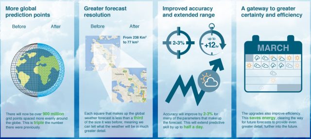
The new upgrade brings about the greatest improvement through the second way, resolution. The model operators have tripled the number of locations in their three-dimensional grid around the world, at the surface and in the atmosphere, for which solved equations produce variables such as wind, temperature, and air pressure. Typically this is done by throwing more computer hardware at the problem, but the ECMWF already has two supercomputing systems that rank in the top 50 of the Top 500 list.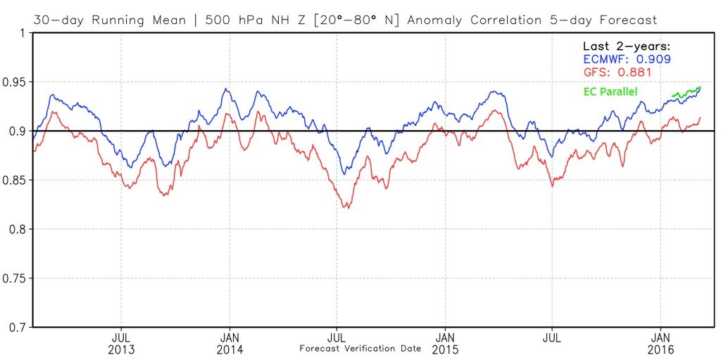
In this case, better resolution has come from changing the way the three-dimensional grid is aligned on Earth, Maue said. Instead of a square box, the forecasted area is broken into cubic octahedrals, increasing the efficiency of the model's calculations. As a result, the spacing between the grid points in the operational model, which is run twice a day to make official forecasts for locations around the globe, has seen a resolution improvement from 14km to 9km. This will allow the model to better capture smaller-scale weather features, such as clusters of thunderstorms.
The improvement will be even greater for the model’s ensemble forecasts. Like other global models, the ECMWF is run about 50 different times during a forecast cycle with slightly different starting conditions. This gives a range of outcomes, and by looking at all of these ensembles, forecasters can get some idea of probabilities. For example, is it likely to be warmer or colder than normal 10 days from now? The change in grid structure will allow the ECMWF to improve its ensemble model resolution from 32km down to 18km.
“These upgrades launched today not only increase the detail of our global operational forecast, its range, and accuracy, but do so in a sustainable way, clearing the way for further improvement,” said Florence Rabier, ECMWF director-general. “This was only achievable through the work ECMWF and its partners are conducting in the field of coding and computing efficiency.”
All about the assimilation
Maue has been tracking the improvement of the upgraded European model, which has been running in an experimental mode for several months, and found that it is performing about 0.5 percent better than the operational version. This will, in effect, widen the gap in performance by 17 percent over the GFS model.
The GFS model will have its own upgrade in May, Maue said, in time for the beginning of the Atlantic hurricane season. And that upgrade may address one of the major differences of the world’s two best models. Unlike the GFS model, the European forecast system uses a technique called 4D-Var to assimilate weather data into its forecasting system, which extracts the maximum value from satellite observations and other sources of atmospheric information. Better initial conditions invariably lead to better forecasts.
The upgrade in May to the GFS model is likely to incorporate this more advanced data assimilation method.
reader comments
64